
iRES Current Research Initiatives
Geographic Information Extraction Using Global Databases
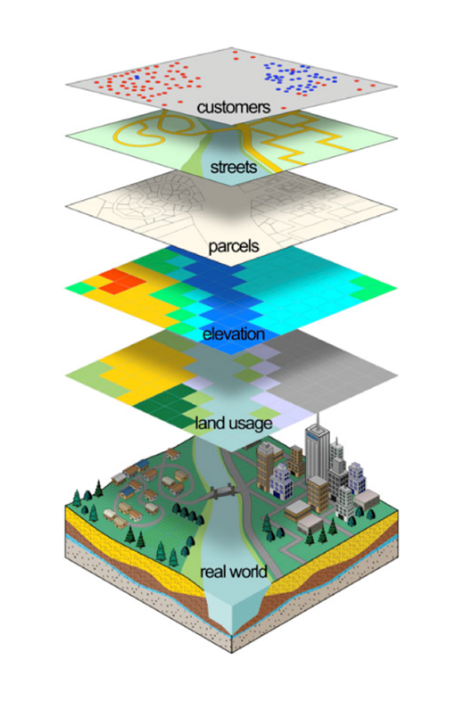
World’s broadcast, print, and web news globally provides near-real-time spatiotemporal information. This information is valuable for extracting geographical locations and associated themes to gain insights into current events. Current tools often lack the ability to make the link between complex variables such as spatial accuracy and contextual references described in media. Many Natural Language Processing (NLP) and Large Language Models (LLMs) using neural network architecture are built to identify diverse sets of co-dependencies and inter-connections between spatial and contextual information. This project aims to better understand large global databases and leverage NLPs and LLMs to categorize media topics, identify-extract spatial locations, catalog date-time of events, and detect spatio-temporal patterns to build dashboards and complex decision-making tools for analysts. The case studies will examine current global conflicts and violence.
Resources
Sentiment Mapping and Perceptions During Times of Peace and War
Center for Geographic Analysis at Harvard University maintains a Geotweet Archive, a global record of tweets spanning time, geography, and language. The archive consists of about 10 billion tweets from 2010 to the present and is updated hourly. Access to geo-coded social media information offers a unique medium to explore multiple behavioral responses of individuals to changes in their natural or political environment during times of peace and war. This project aims to utilize Geotweet data for semantic and sentiment analysis to forecast and better understand the perception of people using areas of conflict and strategic importance. The case studies for this data can be applied to is on various initiatives globally to better understand the true perception and impact on nations.

Resources
Identifying & Evaluating Emerging Technologies in Quantum Sensing
Research and engineering in the quantum domain involve long chains of activity involving theory development, hypothesis formation, experimentation, device prototyping, device testing, and many more. At each stage multiple paths become possible, and of the paths pursued, the majority will lead nowhere. Our quantum sensing initiative provides a strategy which enables all stakeholders to gain an overview of those developments along these tracks, that are relevant to their specific concerns. It provides a controlled vocabulary, built out of terms that are designed to be maximally comprehensible to all groups of stakeholders and across all the sub-fields of the quantum domain.

Unmanned Aerial Systems – Evaluating Consumer Drones for
Wireless Attack Platforms
Research and engineering in the quantum domain involve long chains of activity involving theory development, hypothesis formation, experimentation, device prototyping, device testing, and many more. At each stage multiple paths become possible, and of the paths pursued, the majority will lead nowhere. Our quantum sensing initiative provides a strategy which enables all stakeholders to gain an overview of those developments along these tracks, that are relevant to their specific concerns. It provides a controlled vocabulary, built out of terms that are designed to be maximally comprehensible to all groups of stakeholders and across all the sub-fields of the quantum domain.
Geographic Information Extraction
Using Global Databases
World’s broadcast, print, and web news globally provides near-real-time spatiotemporal information. This information is valuable for extracting geographical locations and associated themes to gain insights into current events.
Sentiment Mapping and Perceptions
During Times of Peace and War
Center for Geographic Analysis at Harvard University maintains a Geotweet Archive, a global record of tweets spanning time, geography, and language. The archive consists of about 10 billion tweets from 2010 to the present and is updated hourly.
Identifying & Evaluating Emerging
Technologies in Quantum Sensing
Research and engineering in the quantum domain involve long chains of activity involving theory development, hypothesis formation, experimentation, device prototyping, device testing, and many more.
Unmanned Aerial Systems – Evaluating
Consumer Drones for Wireless Attack Platforms
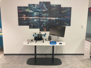
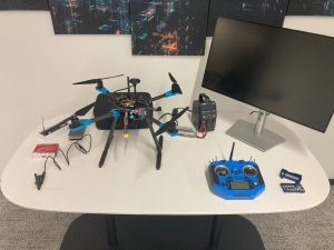
Consumer drones are now widely accessible to the public and can be exploited by malicious actors for remote reconnaissance. With the right components, these drones can be used to launch cyber-attacks on Wi-Fi networks.